Back to Projects

Team Name:

Wattle We Do


Team Members:


Evidence of Work

Wattle Watch

Project Info

Team Name


Wattle We Do


Team Members


Adam , Deanna Veale , Graeme and 5 other members with unpublished profiles.

Project Description


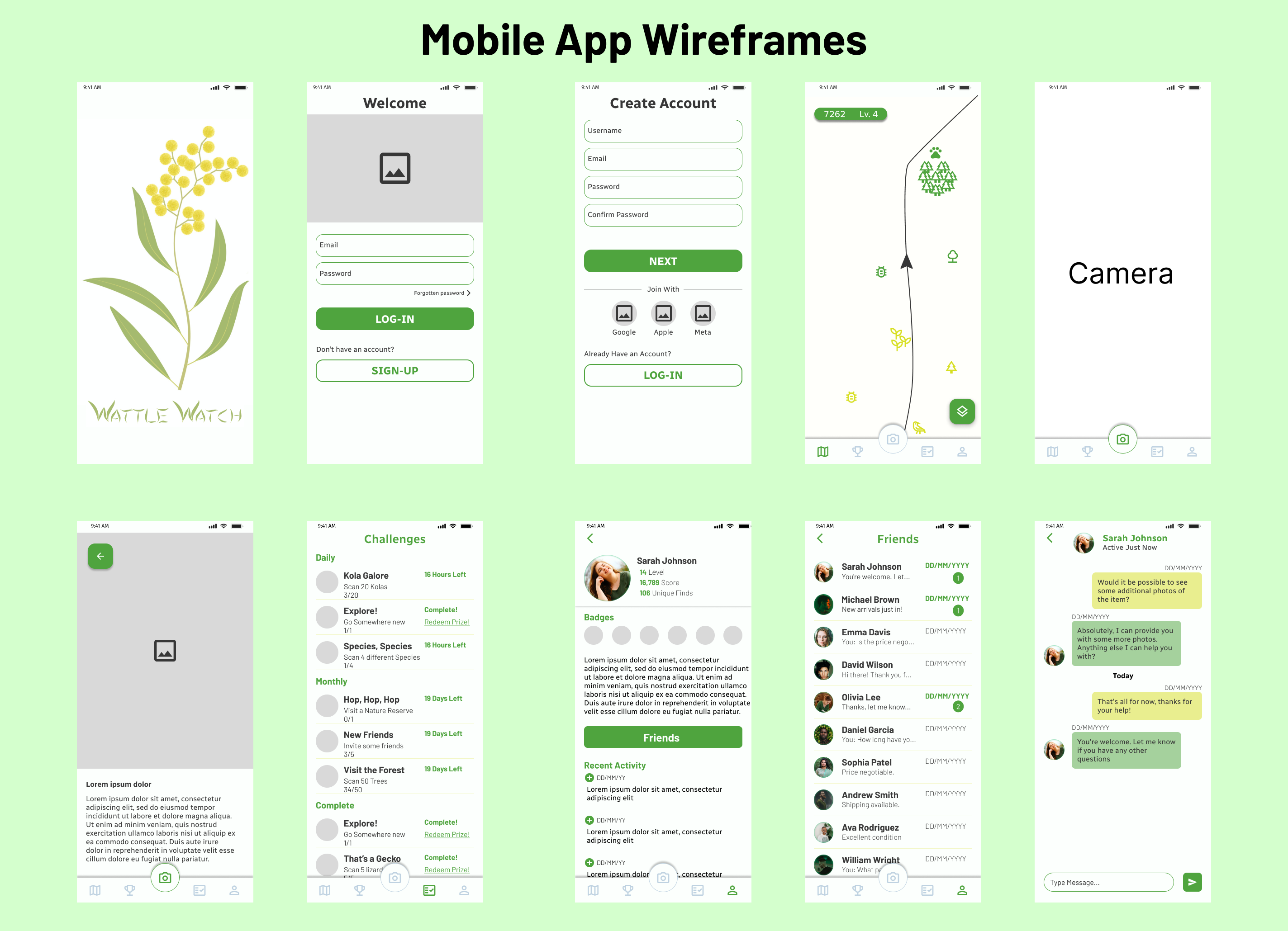
Wattle Watch is an interactive gamified app that encourages people to go outside, explore the wilderness, document their discoveries and interact with other locals about their favourite landmarks. A real-time augmented reality user interface provides users with information about the flora and fauna they encounter. It recognises and augments the image with animals you would expect to see. Users can enter real time challenges where collaboration is encouraged, to gain points and climb their local leaderboards! The app also provides features to leave a digital note on a significant tree for other users to find.

https://github.com/wattlewedo/govhack?tab=readme-ov-file#wattle-watch

Analysis (pdf)

Design

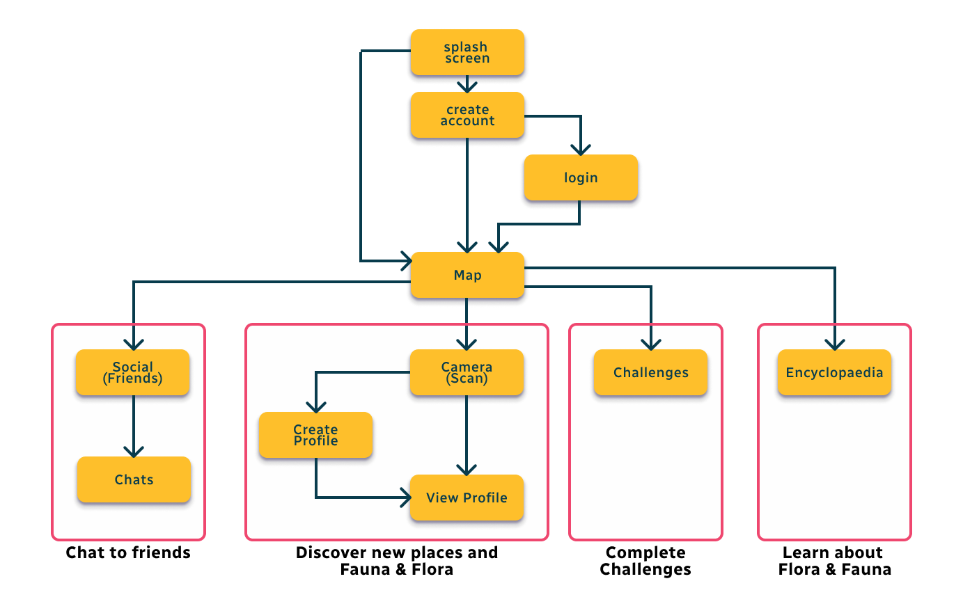
Application navigation
Application wireframes


#web app #augmented reality #social media #gamification

Data Story


We used the shorebird datasets to view changes in roosting areas over the recorded time period. It was found that the resolution of the areas increased substantially over the period. We think this indicates that extra monitoring has improved our understanding of these sites. This is evidence that with monitoring, including crowd sourced and community collected data, comes increased understanding.

We used the koala sighting data to see if we could find evidence of severe threats to koalas. In contrast, we found that sightings have increased but quite a large number of koalas have not been observed in the latest sighting data. There isn't enough information to distinguish between observation activity versus birth/death rates or migration rates. The idea is that a website containing this type of information will enhance the experience for users.

We used the significant tree data to present a map of sites that people might visit. The idea is that other datasets could be layered into the application for people continue to observe the trees and other items discovered by the community.


Evidence of Work

Video

Homepage

Team DataSets

NT Parks and Reserves

Description of Use Used to display the location of Parks and reserves to users of the app as a layer or points of interest

Data Set

Shorebird roosts

Description of Use Attempt to discover whether the number of bird sightings and roosting areas have changed over the period of recordings from 2009 to 2021. We couldn't find the bird count data that the metadata description referred to but were able to show area changes.

Data Set

Koala Monitoring The Mill

Description of Use Analyse koala sightings per year and previously seen koalas that were absent from recent sightings vs koalas that were new in recent sightings.

Data Set

MBRC Planning Scheme - Heritage Landscape Significant Trees

Description of Use Starting set of trees to use for application

Data Set

Challenge Entries

Moreton Bay Greening as We Grow (QLD)

How might we harness the power of the everyday citizen to help protect our diverse flora and fauna as we grow our region, creating a diverse and flourishing planet for generations to come?

Go to Challenge | 16 teams have entered this challenge.

Boosting Tourism in the Northern Territory

How can data be leveraged to create innovative solutions that boost tourism in the Northern Territory, attract more visitors, and/or enhance their cultural experience?

Go to Challenge | 25 teams have entered this challenge.

Civic participation for a more resilient, cohesive democracy.

How can we help more people to understand their democracy, have an opportunity to participate in civic life, contribute to their community, and/or feel a sense of belonging and responsibility?

Go to Challenge | 27 teams have entered this challenge.